

Professionals in the AEC industry constantly ask one critical question: how long does a drone survey take? The answer is more nuanced than a simple timeframe. Understanding the complete timeline of drone mapping, from fieldwork to final deliverables, is essential for project planning and budget allocation. This comprehensive guide explores the duration of drone surveying operations, the efficiency gains over traditional methods, and the technical processes involved in transforming raw aerial data into actionable insights.
What is Drone Mapping and UAV Mapping?
Drone mapping, also known as UAV mapping or aerial mapping, involves using unmanned aerial vehicles equipped with specialised cameras and sensors to capture high resolution imagery and data from above. This technology has revolutionised how professionals in construction, real estate, agriculture, and infrastructure development gather spatial information.
This technology is also becoming a cornerstone for renewable energy projects, particularly through drone-based 3D modeling for solar design, which significantly streamlines site assessment and installation planning.
Drone surveying differs fundamentally from traditional ground-based surveying methods. Rather than surveyors spending days or weeks measuring sites manually, drones can cover large areas in a fraction of the time, collecting data points that are later processed into detailed maps, 3D models, and orthomosaics.
The process combines cutting-edge hardware with sophisticated software to deliver precision data. Two primary technologies dominate the drone mapping landscape:
- Photogrammetry based systems that use overlapping aerial photographs
- LiDAR based systems that use laser pulses to measure distances and create point clouds
Drone Mapping Time: The Fieldwork Phase
Flight Duration and Area Coverage
The actual flight time for a drone mapping mission depends on several critical factors. Most commercial drones have battery lives ranging from 20 to 55 minutes, though newer models can extend this further. However, total mission time extends well beyond the drone flight itself.
A typical drone mapping mission for a small to medium sized site (5 to 50 acres) usually requires:
- 15 to 30 minutes for site assessment and flight planning
- 20 to 45 minutes for actual flight operations
- 10 to 15 minutes for equipment setup and safety checks
- 5 to 10 minutes for data verification and backup
For larger sites exceeding 100 acres, multiple flights become necessary. Each additional flight adds 30 to 45 minutes to the total fieldwork duration. The efficiency of drone surveying becomes increasingly apparent when comparing this timeline to traditional methods.
Weather and Environmental Factors
Drone survey duration is significantly affected by environmental conditions. Wind speeds above 35 kilometres per hour can compromise flight stability and data quality. Cloud cover, precipitation, and temperature extremes all influence fieldwork scheduling and duration.
Professional operators often require contingency days when weather conditions prevent flight operations. This differs markedly from the perception that drones offer rapid results regardless of circumstances. Proper project planning must account for potential weather delays.
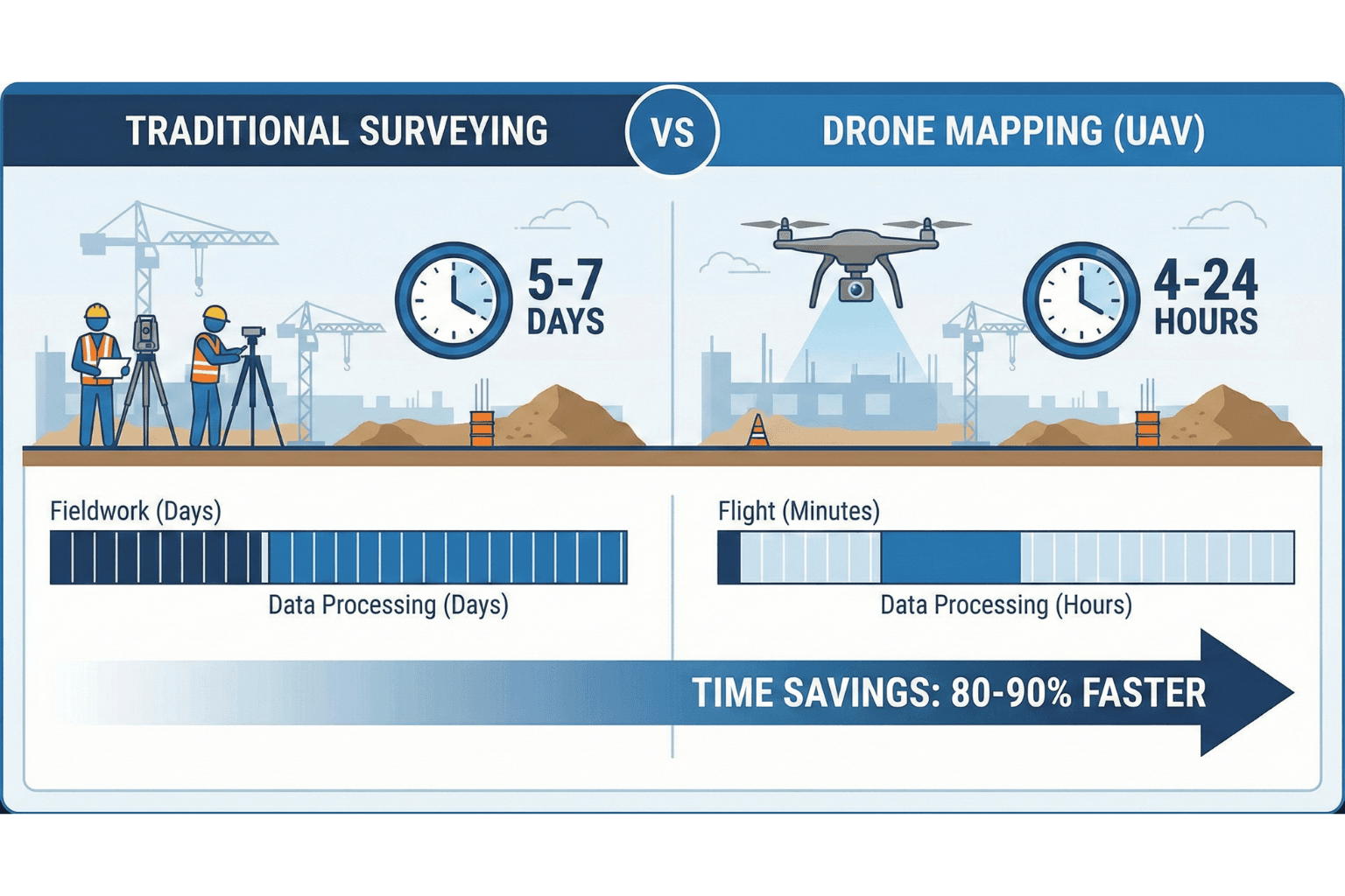
Drone vs Traditional Surveying: Efficiency Comparison
Understanding drone mapping efficiency requires direct comparison with conventional surveying methods. The differences are substantial, particularly regarding human hours required and project timelines.
| Survey Parameter | Traditional Surveying | Drone Mapping | Time Savings |
|---|---|---|---|
| 5 acre site survey | 2 to 3 days (40 to 60 human hours) | 0.5 to 1 day (4 to 8 human hours) | 85% faster |
| 25 acre site survey | 5 to 7 days (100 to 140 human hours) | 1 to 2 days (12 to 20 human hours) | 80% faster |
| 100 acre site survey | 14 to 21 days (280 to 420 human hours) | 2 to 4 days (24 to 40 human hours) | 75% faster |
| Complex terrain mapping | Extremely difficult or impossible | Standard capability | Enables new possibilities |
Drone vs traditional surveying comparisons consistently show dramatic efficiency improvements. Professional surveyors can cover exponentially more area in less time whilst maintaining or exceeding accuracy standards.
Cost Implications of Drone Mapping Efficiency
The efficiency gains translate directly to cost reductions. A traditional survey requiring 100 human hours at £75 per hour costs £7,500. The same area surveyed via drone mapping using 15 human hours costs approximately £1,125 in labour, representing an 85% cost reduction before accounting for equipment and overhead savings.
Drone Data Processing Time: From Raw Data to Deliverables
Fieldwork represents only the initial phase. Drone data processing time constitutes a significant portion of the overall project duration. Understanding this phase is crucial for accurate project scheduling.
Processing Timeline Overview
After drone flights conclude, data undergoes several processing stages:
- Data transfer and backup (30 minutes to 2 hours)
- Image alignment and structure from motion processing (2 to 12 hours)
- Ground control point (GCP) deployment and verification (1 to 4 hours)
- Orthomosaic processing and generation (4 to 16 hours)
- Point cloud generation and classification (4 to 12 hours)
- Quality assurance and final deliverable preparation (2 to 8 hours)
Total drone mapping time from raw data to finished deliverables typically ranges from 24 to 72 hours for standard projects, depending on data volume and processing complexity.
Photogrammetry vs LiDAR Processing
The choice between photogrammetry vs LiDAR significantly impacts processing duration:
| Aspect | Photogrammetry | LiDAR |
|---|---|---|
| Processing time for 100 acre site | 12 to 24 hours | 18 to 36 hours |
| Data file size | 50 to 200 GB | 20 to 60 GB |
| Accuracy (RTK/PPK enabled) | ±2 to 5 cm horizontal | ±3 to 8 cm horizontal |
| Vegetation penetration | Poor | Excellent |
| Orthomosaic quality | High definition imagery | Lower resolution imagery |
Photogrammetry vs LiDAR selection depends on project requirements. Photogrammetry processes faster but LiDAR penetrates vegetation more effectively. Many professionals employ both technologies for comprehensive coverage.
GCP Deployment and Its Impact on Timeline
GCP deployment (Ground Control Points) directly influences accuracy and processing duration. High precision projects require physical GCP markers placed across survey areas before flight operations. These markers are then located in aerial imagery during processing, grounding the data to precise coordinates.
GCP deployment adds 2 to 6 hours of fieldwork for typical sites but improves horizontal accuracy to ±2 centimetres when combined with RTK (Real Time Kinematic) technology. This investment in field time often proves worthwhile for projects where precision is paramount.
Advanced Processing Considerations
Specialised processing requirements extend timelines. Orthomosaic generation for large areas may require 8 to 16 hours of processing time. Point cloud generation and subsequent 3D model creation can consume 4 to 20 hours depending on complexity and desired detail levels.
Professional drone surveying operations typically maintain high quality standards throughout processing. Automated checks verify data integrity, accuracy thresholds, and deliverable specifications before final handover.
Real World Timeline Examples
Practical examples illustrate how drone mapping timelines vary across common scenarios:
Small Construction Site Survey (8 Acres)
- Site preparation and flight planning: 1 hour
- Drone flights and data capture: 1 hour
- Data processing: 18 hours
- Quality assurance: 2 hours
- Total timeline: 22 hours (2 to 3 business days)
Large Commercial Development (60 Acres)
- GCP placement and verification: 6 hours
- Site preparation and flight planning: 2 hours
- Multiple drone flights: 4 hours
- Data processing: 32 hours
- Quality assurance and revisions: 4 hours
- Total timeline: 48 hours (5 to 7 business days)
Complex Infrastructure Project with Vegetation (120 Acres)
- GCP placement including challenging terrain: 8 hours
- Dual sensor deployment planning: 3 hours
- Flight operations with LiDAR and photogrammetry: 6 hours
- Data processing and point cloud generation: 48 hours
- Quality assurance and multiple revisions: 6 hours
- Total timeline: 71 hours (10 to 14 business days)
Factors Influencing Total Drone Survey Duration
Site Characteristics
Terrain complexity directly impacts how long does a drone survey take. Flat urban sites with clear boundaries process rapidly. Mountainous terrain, dense vegetation, or complex infrastructure requires additional flight time and more sophisticated processing algorithms.
Data Requirements and Deliverables
Projects requiring only basic orthomosaics complete faster than those needing detailed 3D models, classified point clouds, or volumetric calculations. Defining exact deliverable specifications before fieldwork ensures realistic timeline estimates.
Equipment and Processing Resources
Advanced drone platforms equipped with RTK receivers and multi-spectral sensors produce superior data but require longer processing times. Conversely, older generation drones process faster but may require additional field revisits for accuracy verification.
Processing hardware capabilities significantly affect drone data processing time. High performance workstations with modern GPUs complete processing tasks in half the time of older systems.
Regulatory and Compliance Requirements
Depending on location and airspace classification, obtaining flight permissions may require days or weeks of coordination. Professional operators account for regulatory timelines when providing project schedules.
Optimising Drone Mapping Efficiency
Experienced professionals employ several strategies to maximise drone mapping efficiency:
- Comprehensive pre flight planning including weather monitoring and airspace checks
- Strategic flight pattern design to optimise coverage and minimise redundancy
- Proper GCP placement before flights commence rather than post processing adjustments
- Using high quality sensors appropriate for project requirements
- Implementing automated quality checks throughout processing stages
- Maintaining up to date processing software and hardware
- Clear communication with clients regarding realistic timelines and deliverable specifications
Industry Standards and Best Practices
Professional drone mapping adheres to established standards ensuring reliability and accuracy. Standards organisations have published guidelines for aerial surveying, establishing minimum requirements for equipment, procedures, and accuracy thresholds.
For AEC professionals relying on drone data for critical decisions, understanding these standards provides confidence in deliverable quality. Certified operators maintain ongoing training and adhere to rigorous quality control protocols throughout all project phases.
The integration of drone mapping with traditional surveying creates complementary workflows where each method’s strengths address the other’s limitations. This hybrid approach increasingly dominates professional surveying practice, particularly for large complex projects.
Frequently Asked Questions
How long does a drone survey take for a 50 acre property?
A 50 acre property typically requires 8 to 16 hours of total project time including fieldwork and basic processing. With premium deliverables and GCP deployment, expect 24 to 48 hours total duration.
What is the difference between photogrammetry and LiDAR processing times?
Photogrammetry generally processes 20 to 30 percent faster than LiDAR for equivalent datasets. However, LiDAR provides superior results in vegetated areas and can penetrate dense foliage where photogrammetry struggles.
Can drone mapping be completed in a single day?
Small sites under 10 acres with simple requirements can be completed in one business day from survey to final deliverables. Larger sites or projects requiring high precision GCP deployment typically require multiple days for fieldwork and processing.
How does RTK/PPK accuracy impact processing time?
RTK (Real Time Kinematic) and PPK (Post Processed Kinematic) systems add 1 to 2 hours to fieldwork but reduce processing requirements by eliminating GCP placement. Overall project time often remains similar whilst accuracy improves significantly.
What factors most significantly influence drone mapping duration?
Site size, terrain complexity, weather conditions, required accuracy, and deliverable specifications most significantly impact total duration. Vegetation density and airspace restrictions also influence project timelines substantially.
Is drone mapping faster than traditional surveying for all project types?
Drone mapping provides dramatic time savings for most applications. However, certain small precise tasks like boundary surveys or utility locating may complete faster using traditional methods. A hybrid approach often optimises overall efficiency.
How long does orthomosaic processing take?
Orthomosaic processing for a 50 acre site typically requires 4 to 8 hours depending on image resolution, overlap percentages, and processing hardware capabilities. Advanced techniques like seamless blending and colour correction extend processing time.
Can I get drone mapping results immediately after flight?
Whilst preliminary results can be generated within hours, final publication ready deliverables require proper processing and quality assurance. Expect minimum 12 to 24 hours for complete professional results even for small sites.
Conclusion
Understanding drone mapping duration requires appreciating both fieldwork and data processing components. From initial site assessment through final deliverable presentation, drone survey duration typically spans 24 to 72 hours for standard projects, representing dramatic efficiency improvements over traditional methods.
For AEC professionals planning projects, the key takeaway is that drone mapping time delivers substantial value beyond simple speed metrics. The combination of rapid data collection, comprehensive spatial coverage, and high accuracy information creates competitive advantages in project planning, design development, and construction management.
The choice between photogrammetry vs LiDAR, integration of GCP deployment strategies, and investment in quality processing resources all influence the timeline and ultimate value of drone surveying work. Experienced operators balance speed with accuracy, understanding that rushing through data processing compromises the very benefits that made drone mapping attractive initially.
As drone technology continues advancing, processing speeds improve and capabilities expand. Professionals who understand current timelines and capabilities can integrate aerial mapping effectively into their workflows, capturing significant competitive advantages whilst delivering superior results to their clients.
For organisations seeking to implement professional drone mapping solutions, partnering with experienced specialists ensures realistic timelines, superior data quality, and deliverables that truly enhance project outcomes. The investment in proper drone surveying methodology consistently pays dividends across project phases, from design through construction completion.
To explore comprehensive 3D modeling and drone mapping solutions, visit Render A’s 3D Modeling Solutions, where specialists deliver professional aerial surveying and data processing services tailored to construction and infrastructure projects. For more information about industry practices, connect with professionals on Render A’s LinkedIn profile.


