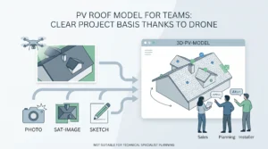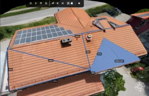


Drone photogrammetry helps solar teams build a clearer view of a site before design and proposal work begins. Instead of relying only on notes, satellite imagery or a limited set of roof photos, a planned drone capture can provide a reviewable 3D representation of visible roof surfaces, obstacles and surrounding context.
This guide explains how photogrammetry for solar fits into a solar site survey workflow, what to check before using a model for planning and where project-specific verification is still needed.
What is photogrammetry for solar?
Photogrammetry for solar is the use of overlapping aerial images to create a three-dimensional representation of a roof or site. Solar teams can use that representation to review visible roof geometry, identify potential obstructions and prepare for the next stage of project planning.
It is not a fixed-result process. The usefulness of a 3D model depends on the capture plan, the quality of the original images, the visibility of the site, the processing workflow and the checks completed before measurements are relied on.
Why solar teams use drone photogrammetry
Solar projects often begin with incomplete site information. Aerial drone data collection can give sales, design and operations teams a shared view of the same roof before making early layout or proposal decisions.
- Review visible roof areas, roof shapes and access constraints from a single project view
- Identify visible features such as chimneys, HVAC equipment, parapets, skylights and nearby trees
- Prepare more focused follow-up questions before a site visit or technical review
- Document the site condition at the time of the survey
- Give solar teams a clearer starting point for design discussions and client communication
A drone roof survey can reduce the need to collect every early-stage observation by hand on a roof. It does not remove the need for safe flight operations, appropriate permissions, qualified review or any site verification required for the project.
1. Start with the solar site survey brief
Before flying, define what the solar project team needs to learn from the survey. A roof with multiple levels, vegetation, roof-mounted equipment or limited access may require a different capture approach from a simple, unobstructed roof.
Useful questions to agree before the flight include:
- Which roof surfaces need to be reviewed for the project?
- Which visible obstacles, roof edges or access areas may affect the design discussion?
- Are there areas hidden by adjacent structures, vegetation or roof geometry?
- Will the model be used for an early proposal, a design review or a further site inspection plan?
- Which measurements or decisions need an additional project-specific check?
For a broader capture and measurement workflow, see drone roof survey and measurement for solar projects.
2. Capture images for a usable 3D model
Drone mapping for solar begins with a complete and consistent image set. Keep the original image files and plan the capture around the surfaces that must be visible. A model cannot reliably show a roof area that was not captured clearly.
During drone data collection, review:
- Whether the required roof surfaces and relevant surroundings are visible
- Whether images are sharp enough to review important visible features
- Whether the route includes useful viewing angles for complex roof geometry
- Whether weather, shadows, glare, vegetation or access restrictions limit what can be seen
- Whether original photo files and available metadata have been retained
There is no universal photo count that works for every solar site. The required capture changes with roof size, roof geometry, camera setup, project objective and the level of detail needed for the next decision.
Before submitting a project, use the Drone Flight Route Viewer to review available photo locations and flight-route geometry. This is a capture-review step, not a reconstruction, accuracy or coverage guarantee.
3. Review the 3D model before using it for solar planning
Once the model is available, review it against the purpose set in the site survey brief. Look for missing roof areas, unclear boundaries, obstructed surfaces, blurred zones and elements that may be difficult to interpret from aerial imagery alone.
Questions to ask during model review
- Are the roof surfaces relevant to the project visible and complete enough for the intended use?
- Are visible obstacles and roof features represented clearly enough for a design conversation?
- Are there shadows, reflective materials, vegetation or narrow spaces that make a feature uncertain?
- Do known site references or subsequent checks agree with the critical information in the model?
- Does the project require a qualified surveyor, installer, engineer or site visit to verify a decision?
Use the model to focus the next action. If an area is uncertain, document the limitation and verify it through the appropriate project process rather than treating the model as a guarantee.
4. Move from the model to a solar proposal workflow
A reviewed 3D model can help a solar team organise the information needed before a proposal is prepared. It can provide a shared reference for discussing roof areas, visible obstacles, access constraints and the questions that must be resolved before final design.
For proposal preparation, the important distinction is between information that is visible in the model and information that has been verified for the project. Measurements, product selection, pricing, energy assumptions, structural requirements and installation constraints should follow the team’s normal approval process.
Learn how a measured 3D project view can support the next commercial step in proposal preparation from 3D models.
5. Keep safety and verification in the workflow
Drone technology can enable teams to inspect many visible roof conditions without putting every early-stage reviewer on the roof. The drone operation itself still requires competent planning, safe execution and compliance with applicable local rules.
Photogrammetry also has limits. Hidden surfaces, image quality problems, temporary site conditions, reflective materials, vegetation and complex geometry can affect what the model shows. For safety-critical, engineering, contractual or regulatory decisions, use the project’s required verification process and qualified professionals.
Where solar photogrammetry fits in the wider workflow
Photogrammetry is one stage in a connected workflow, not a replacement for every design or installation task. Render-a helps teams create and review a 3D project view before progressing to the next appropriate action.
- Roof measurement: review roof surfaces and visible site features. Explore drone roof measurement for solar.
- 3D project modelling: view the broader range of Render-a 3D modeling solutions.
- Solar proposals: use verified project information to support the commercial workflow. Explore proposal preparation from 3D models.
Frequently asked questions
Can drone photogrammetry be used for a solar site survey?
Yes. A planned drone capture can help solar teams review visible roof geometry, obstructions and surrounding site context. The capture and review process should be adapted to the specific project and the decisions the team needs to make.
Does drone photogrammetry make roof access unnecessary?
It can reduce the need for some early-stage roof access by giving the team a remote view of visible conditions. It does not eliminate operational safety responsibilities, project-specific checks or any verification required for installation and engineering decisions.
How accurate is a solar photogrammetry model?
Accuracy and suitability depend on the capture method, equipment, site visibility, quality controls and the intended use. Critical measurements should be verified through the appropriate project process rather than assumed from a general accuracy claim.
Can the model be used directly for a solar proposal?
A reviewed model can support early proposal preparation by helping teams discuss roof geometry and visible site conditions. Final proposals should use verified information for the pricing, system design, energy assumptions and installation scope.
Plan a clearer solar site survey
Drone photogrammetry can give solar teams a stronger starting point for site review, planning and client conversations. Define the survey objective, capture the right images, review the model carefully and verify the information that matters before moving to final decisions.
Explore Render-a and start a demo project.