

“The future of surveying is not about choosing between technologies, but understanding which tool solves your specific problem.” As a senior geomatics engineer with over a decade of experience in aerial and terrestrial surveying, I’ve watched the industry transform fundamentally. Today’s question isn’t whether drones work it’s whether they work better than established methods for your project. The answer is nuanced, and it matters far more than marketing materials suggest.
Direct Answer: Drone Survey Accuracy Today
With modern Real-Time Kinematic (RTK) or Post-Processed Kinematic (PPK) modules, drone surveys achieve 1 to 3 centimetres relative accuracy, making them directly comparable to traditional GPS surveying. However, this precision requires careful workflow management, including the strategic placement of Ground Control Points (GCPs) and proper flight planning. Without these controls, standard drone surveys deliver approximately 5 to 10 centimetres accuracy, sufficient for many applications but inadequate for precise structural monitoring or property boundary documentation.
Understanding Drone Mapping and Photogrammetry Accuracy
Drone mapping systems rely primarily on photogrammetry, which derives spatial measurements from overlapping aerial photographs. The accuracy of this process depends on several interconnected factors. Ground Sampling Distance (GSD), which represents the physical distance between pixels in your imagery, fundamentally limits positional accuracy. At 100 metres altitude with a typical commercial drone camera, GSD might be approximately 2.5 centimetres per pixel, meaning your theoretical horizontal accuracy hovers around 5 centimetres before post-processing refinements.
Photogrammetry accuracy isn’t merely about camera resolution it’s about geometric consistency. Modern photogrammetry engines process thousands of image-derived tie points, triangulating their positions in three-dimensional space. When those calculations are anchored to surveyed Ground Control Points, the entire model can be shifted and scaled to match real-world coordinates. This constraint dramatically improves accuracy from relative measurements to absolute positioning, transforming a drone survey from a pretty map into actionable data.
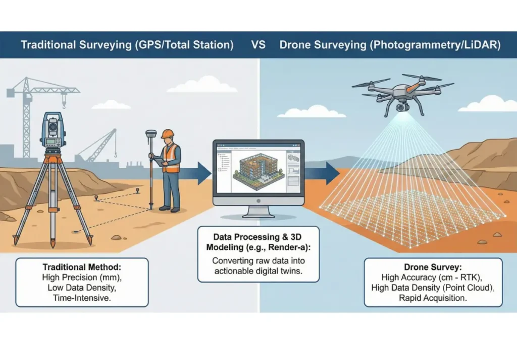
GPS Survey vs Drone Survey: A Balanced Comparison
This comparison demands nuance because the technologies address different challenges. Traditional GPS surveying, whether static or real-time kinematic, provides point-specific positioning with exceptional accuracy. A skilled GPS technician can establish horizontal accuracy to within 1 centimetre and vertical accuracy to within 2 centimetres at a single location. The limitation emerges in coverage: mapping a 50-hectare site with GPS requires days of fieldwork, establishing reference points systematically across the entire area.
Drone surveys, conversely, capture complete aerial datasets in a single flight lasting 15 to 25 minutes. From these datasets, you extract positional data for unlimited points. The trade-off is slightly reduced precision for dramatically increased coverage efficiency. For topographic surveys, volumetric calculations, or orthomosaic map generation, this exchange favours drones decisively. For establishing precise boundary markers or monitoring millimetre-scale structural settlement, traditional GPS methods remain superior.
| Survey Method | Horizontal Accuracy | Vertical Accuracy | Coverage Area (Daily Capacity) | Best For |
|---|---|---|---|---|
| Drone (RTK/PPK) | 1 to 3 cm | 2 to 5 cm | 50 to 200 hectares | Topography, volumetrics, orthomosaics |
| GPS (RTK) | 2 to 5 cm | 3 to 8 cm | 5 to 20 hectares | Boundary stakes, control networks |
| Total Station (Conventional) | 5 to 10 mm | 8 to 15 mm | 0.5 to 2 hectares | Structural monitoring, precise detail work |
| LiDAR (UAV-mounted) | 5 to 15 cm | 5 to 20 cm | 100 to 300 hectares | Dense vegetation, bare earth models |
The Critical Role of Ground Control Points in Aerial Surveying
Understanding GCPs separates competent drone operators from those producing unreliable data. A Ground Control Point is a precisely surveyed location on the ground, identified in aerial imagery, used to georeference the entire dataset. Without GCPs, drone photogrammetry produces internally consistent models but with undefined absolute position. Think of it as a perfectly detailed photograph with no indication of where the photograph was taken.
Professional drone surveys typically require GCPs distributed across the survey area at a ratio of approximately one GCP per 10 to 15 hectares. These points are established using conventional GPS equipment or total stations, incurring additional cost and fieldwork time. This requirement directly addresses why drone surveys can’t simply replace GPS entirely: the most accurate drone deliverables actually depend on supplementary GPS work for their highest accuracy levels.
Land Surveying Methods: Integration Rather Than Competition
Contemporary surveying practice isn’t about exclusive method selection but intelligent integration. A major infrastructure project might employ:
- Drone photogrammetry for rapid site-wide topographic data capture
- Total station surveys for precise structural detail and monitoring
- GPS networks for establishing control points anchoring the entire project coordinate system
- LiDAR point clouds for vegetation-penetrating elevation data
Each method contributes specialised capabilities. Aerial surveying via drones excels at large-area rapid assessment and volumetric calculations. Traditional land surveying methods excel at precision detail work and legal boundary definition. The distinction isn’t superiority but suitability to task requirements.
LiDAR and Advanced Aerial Surveying Techniques
LiDAR (Light Detection and Ranging) represents an evolution beyond photogrammetry in aerial surveying. Rather than deriving positions from image overlaps, LiDAR directly measures distance using laser pulses. This technology penetrates dense vegetation, capturing bare earth topography where photogrammetry would see only canopy. Accuracy typically ranges from 5 to 20 centimetres horizontally and 5 to 20 centimetres vertically, slightly less precise than RTK drone surveys but exceptional for complex terrain.
The advantage manifests dramatically in forested or undergrowth-heavy environments. Where photogrammetry might produce a surface model representing vegetation tops, LiDAR generates discrete point clouds distinguishing individual trees and ground elevation. For hydrological studies, forestry applications, or archaeological surveys, LiDAR’s penetration capabilities justify the increased equipment and processing costs.
Real-World Accuracy Performance: Construction Site Example
Consider a 60-hectare commercial development site requiring baseline topography, volumetric calculations for cut and fill operations, and progress monitoring across three years. A drone survey with RTK correction and twelve strategically positioned GCPs will produce:
- Orthomosaic imagery accurate to 2 centimetres horizontal resolution
- Digital elevation models with 5 centimetre vertical accuracy
- Volumetric calculations accurate to within 2 to 3 percent of surveyed quantities
- Complete baseline documentation captured in five hours of field time
Conventional GPS surveying of the same site would require fifteen to twenty days of fieldwork to achieve comparable coverage. Total station methods would require months. The drone delivers comprehensively superior efficiency whilst maintaining accuracy specifications suitable for engineering design and contractual documentation.
The Data Processing Challenge: Where Accuracy Is Realised or Lost
Here’s where the industry narrative diverges sharply from reality: collecting accurate data and processing that data into usable formats are entirely distinct challenges. A drone flight generates tens of thousands of raw images. Transforming these into georeferenced orthomosaics, digital elevation models, and volumetric reports requires sophisticated photogrammetry software, skilled operators, and strict quality control protocols.
Many organisations capture drone data but lack the internal capacity for rigorous post-processing. The consequences include compromised accuracy, undetected processing errors, and loss of the precision inherent in the original flight data. This represents a critical juncture where specialist expertise becomes essential. Partners equipped with industry-standard photogrammetry workflows, point cloud processing capabilities, and BIM integration expertise ensure that survey accuracy achieves its full potential in final deliverables.
Render-a’s precision 3D modeling solutions address precisely this bottleneck. Beyond simple orthomosaics and point clouds, professional workflows demand conversion of survey data into actionable CAD and BIM models, preserving accuracy whilst adding geometric intelligence. This transformation requires expertise spanning photogrammetry, surveying standards, and engineering documentation conventions. By engaging specialised partners for data processing, organisations ensure that drone survey accuracy translates directly into project value rather than remaining locked in raw datasets.
Factors Influencing Drone Survey Accuracy
Achieved accuracy depends on multiple controllable and environmental variables:
- Flight altitude: Lower altitudes yield finer GSD and better accuracy but reduce coverage per flight
- Image overlap: Minimum 80 percent forward overlap and 60 percent lateral overlap ensure robust photogrammetry
- GCP distribution: Strategic positioning throughout the survey area rather than clustering at perimeter
- Atmospheric conditions: Wind, haze, and poor lighting degrade image quality and tie point matching
- Ground surface characteristics: Repetitive patterns and featureless areas reduce photogrammetric stability
- Processing software calibration: Camera model accuracy and lens distortion correction directly impact results
- RTK/PPK availability: Correction signal quality and satellite geometry influence absolute positioning
Accuracy Standards and Industry Compliance
The geomatics industry references established accuracy standards, particularly the American Society for Photogrammetry and Remote Sensing (ASPRS) accuracy classes. These define acceptable tolerance ranges based on Ground Sampling Distance and application type. An ASPRS Class 1 specification demands horizontal accuracy of one-third of the GSD, effectively requiring RTK correction and comprehensive GCP networks to achieve.
Understanding these standards matters because they distinguish between marketing claims and genuine capability. A service provider asserting sub-centimetre accuracy on a 50-hectare survey without comprehensive control networks is either misrepresenting their methodology or misunderstanding fundamental photogrammetry principles. Genuine high-accuracy work involves rigorous protocols and auditable quality control.
When Drones Aren’t the Right Choice
Balanced assessment requires identifying situations where drone surveys underperform:
- Structural monitoring of buildings: Millimetre-level precision demands total station or laser scanning from fixed positions
- Underground utilities: Drones can’t detect buried pipes or cables
- Property boundary surveys: Legal requirements often demand total station or GPS verification by licensed surveyors
- Dense urban environments: Regulatory restrictions and multipath GPS errors complicate drone and satellite-based methods
- Small, detailed features: At project scales under one hectare, drone mobilisation overhead often exceeds benefits
Future Developments in Aerial Surveying Accuracy
Technology evolution continues advancing drone survey capabilities. Integration of multiple sensors (simultaneous RGB photogrammetry and LiDAR), improved RTK correction networks, and artificial intelligence-enhanced point cloud processing are expanding accuracy and application scope. However, the fundamental physics of photogrammetry won’t change: accuracy will always scale with image quality, GCP distribution, and processing rigor.
Frequently Asked Questions About Drone Survey Accuracy
Q: Can drone surveys replace GPS surveys entirely?
No. Drone surveys excel at areal coverage and rapid topographic documentation. GPS surveys provide surveyor-grade point positioning and are still necessary for establishing control networks that anchor drone data to real-world coordinates. The most accurate drone workflows actually incorporate GPS-surveyed GCPs as essential components.
Q: How many Ground Control Points do I actually need?
Industry practice suggests one GCP per 10 to 15 hectares, distributed across the survey area rather than clustered at edges. For 5-hectare sites, minimum three to four GCPs positioned at varied elevations provides adequate constraint. Larger areas benefit from higher GCP densities, particularly in variable terrain.
Q: What’s the difference between relative and absolute accuracy?
Relative accuracy describes consistency of measurements within the survey (distances between points are accurate to your specification). Absolute accuracy describes positioning within a defined coordinate system (points are located correctly relative to known reference points). High-accuracy drone surveys require both: RTK/PPK systems ensure absolute accuracy; photogrammetry rigor ensures relative accuracy.
Q: Why is processing time such a bottleneck in drone surveying?
Modern drones generate 1000 to 3000 images per flight. Photogrammetry processing requires matching equivalent features across overlapping images, triangulating their three-dimensional positions, and refining through iterative adjustment. A single hectare of high-resolution coverage might involve millions of calculations. Robust processing demands optimised software, adequate computational resources, and quality control verification at multiple stages.
Q: Can LiDAR achieve better accuracy than photogrammetry-based drone surveys?
For dense vegetation environments, LiDAR’s ground-penetrating capability delivers superior bare-earth models. For open terrain, modern RTK photogrammetry typically achieves slightly better absolute accuracy. The choice depends on your specific vegetation and accuracy requirements rather than inherent superiority of either method.
Q: Do I need a licensed surveyor to validate drone survey accuracy?
Professional validation by a licensed surveyor provides legal defensibility and quality assurance, particularly for projects with contractual or regulatory implications. For internal planning or preliminary design, in-house validation may suffice if your team has appropriate technical expertise and quality control protocols.
Drone Surveys in the Modern Surveying Landscape
Drone surveys have fundamentally transformed surveying capability, particularly for rapid large-area data capture. With RTK/PPK correction and proper Ground Control Point implementation, they achieve 1 to 3 centimetre accuracy comparable to traditional GPS methods, whilst delivering ten to fifty times greater coverage efficiency. However, they don’t universally replace established techniques; rather, they complement them within integrated workflows.
The practical advantage of modern drones emerges not from claiming absolute superiority but from recognising their distinctive strengths: rapid mobilisation, comprehensive areal documentation, and seamless integration of orthomosaic imagery with precise elevation data. These capabilities unlock entirely new project possibilities, from progress monitoring to precise volumetric calculations, whilst maintaining accuracy standards required for engineering practice.
Critical success factors remain constant: rigorous flight planning, strategic GCP placement, quality-assured post-processing, and integration within broader surveying methodology. These aren’t optional refinements but essential components of professional practice. When executed properly, drone surveys deliver genuine efficiency gains without accuracy compromise, justifying the method’s rapid adoption across infrastructure, construction, and environmental sectors.
The next evolution in surveying excellence involves not choosing between methods but orchestrating their complementary strengths. Your specific project requirements coverage area, required precision, terrain complexity, and regulatory constraints determine the optimal methodology. Modern surveying leadership means understanding these distinctions deeply enough to deliver measurably superior results, whether that involves drones, conventional GPS, total stations, or intelligent combinations thereof.
Ready to ensure your survey data reaches its full potential? Render-a’s precision 3D modeling solutions transform survey datasets into actionable CAD and BIM models that preserve accuracy whilst adding geometric intelligence. Discover how specialised processing workflows can maximise your aerial surveying investment.
Youtube Videos: Render-a Youtube


