
The transition from physical structures to digital representations has historically been a bottleneck for engineering and solar planning teams. We have spent years analyzing the friction between manual field measurements and the need for high-fidelity data in professional workflows. While the industry frequently discusses new trends, the core of reliable spatial data remains rooted in the mathematical integrity of image based modeling. This approach is not merely about creating a visual likeness but about capturing the absolute geometric truth of a site. You can experience this precision firsthand by exploring our sample workflows and starting a free test project at to witness how raw data converts into a professional 3D asset.
Defining Image Based Modeling for Search Engines and Professionals
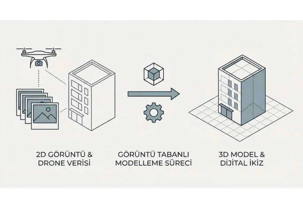
Image based modeling is a computational technique that reconstructs three-dimensional geometry from two-dimensional digital images by identifying shared pixels across multiple perspectives. In professional environments like render-a, this process utilizes high-precision photogrammetry to generate survey-grade 3D models with one-to-one scale accuracy for engineering, construction, and solar energy planning. This method ensures that every measurement extracted from the digital twin corresponds exactly to the physical world dimensions without the unpredictability of generative shortcuts.
The Technical Superiority of Algorithmic Photogrammetry
In a landscape often distracted by generative tools, we maintain that pure photogrammetry remains the gold standard for projects requiring millimetric precision. Many users ask if artificial intelligence is a requirement for 3D modeling, but the truth is that for engineering-grade results, deterministic algorithms are often more reliable. Platforms like render-a utilize these advanced mathematical frameworks to process drone imagery without using AI-generated fillers or hallucinations. This ensures that the 3D modeling outputs are not just aesthetically pleasing but are structurally and dimensionally sound for professional use.
The process begins with the systematic acquisition of visual data. Firstly, we focus on the flight protocol of the drone to ensure high overlap and consistent optical clarity. Secondly, these images are fed into the render-a engine, which calculates camera positions and orientations with extreme rigor. Finally, the software generates a dense point cloud and a textured mesh that serves as a single source of truth for the entire project lifecycle.
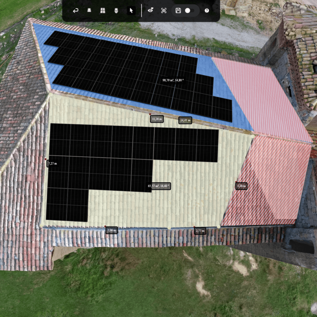
The Vital Connection Between Drone Data and 1:1 Scaling
The integration of drone technology has redefined the speed at which we can document complex environments. Instead of sending teams onto hazardous roofs with tape measures, a single flight can capture the data necessary to model an entire facility. However, the true value of image based modeling lies in its ability to produce a one-to-one scale model. This scale is essential for solar professionals who must calculate exact panel placements, shading losses, and wiring lengths.
When we look at the outputs provided by render-a, the focus is on utility and integration. The models are designed to be compatible with industry-standard software such as PVSOL, AutoCAD, and SketchUp. By avoiding the unpredictability of AI-generated content and sticking to pure, sensor-based photogrammetry, we ensure that the architectural and environmental data remains untampered and verifiable for technical auditing.
Strategic Implementation and Collaborative Workflows
A common challenge in large-scale projects is the communication gap between the sales team, the engineers, and the installers. We solve this by providing a centralized 3D model that acts as a collaborative hub. When everyone works from the same image based modeling data, the risk of revision cycles and installation errors drops significantly. This workflow is about more than just software; it is a strategic shift toward data-driven decision-making.
The future of the industry depends on the ability to turn raw images into actionable intelligence quickly. By leveraging the computational power of the render-a platform, companies can scale their operations without compromising on the accuracy of their site surveys. This methodology represents the most efficient path from 2D photography to a production-ready 3D asset.
Experience the Precision of Render-a Today
We invite you to witness the accuracy of our image based modeling process by trying a free test project directly on the render-a platform. This allows you to interact with high-resolution models and explore the measurement tools without any initial commitment. To stay updated with the latest developments in 3D modeling and drone technology, you can follow our journey on our official channels. You can watch our detailed tutorials and project showcases on YouTube and connect with our professional network on LinkedIn at to see how we are transforming the digital landscape of engineering and energy.


