
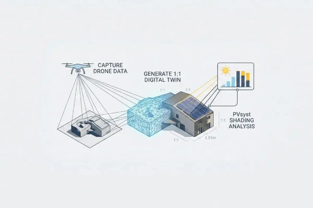
The success of a solar energy project is fundamentally tied to the accuracy of its initial site assessment. In the current engineering landscape, the gap between a theoretical simulation and the actual energy yield often stems from the fidelity of the site model. Traditional methods, which frequently rely on manual measurements or low-resolution satellite imagery, are no longer sufficient for high-stakes installations. To achieve truly bankable results, the industry is transitioning toward photogrammetric rendering, a sophisticated process that converts high-resolution drone data into a precise and functional digital twin.
For professional engineering teams, the Render-a to PVsyst workflow is a technical necessity rather than a luxury. By leveraging 1:1 scale automated modeling, developers can bypass the inherent limitations of manual CAD drafting and bring the as-built reality of a site directly into their simulation environment with millimetric precision.
High-Resolution Drone Data as the Foundation of Digital Twins
The development of a high-fidelity 3D modeling PV design begins with a comprehensive aerial survey. Standard land surveys often overlook subtle but critical details, such as the exact slope of a parapet wall or the precise height of an HVAC unit on a crowded industrial roof. A professional drone roof survey solves this by capturing thousands of data points from multiple angles, ensuring that no structural detail is missed.
Once these images are processed through photogrammetric algorithms, they form a digital twin. This is not merely a visual representation but a geometrically identical replica of the project site. The primary advantage of this method is the 1:1 scale automated nature of the output. Unlike manual tracing, which is prone to human error, the software ensures that every unit in the digital world corresponds exactly to the physical world. This precision is vital for avoiding panel collisions and ensuring that the final installation matches the engineering plans perfectly.
The Technical Bridge: Optimizing OBJ and DAE Formats for PVsyst
A common challenge in this workflow is transferring high-density photogrammetric models into PVsyst without compromising software performance. While PVsyst is the industry standard for energy reports, its internal shading engine is not designed to handle raw meshes containing millions of polygons. The solution lies in the strategic use and optimization of OBJ and DAE file formats.
The OBJ format is the primary choice for maintaining geometric integrity. It captures the precise vertices and faces of a roof or complex terrain, ensuring that the shading scene is a true reflection of reality. On the other hand, the DAE or Collada format is often utilized when a scene requires complex hierarchies or specific object orientations, making it ideal for urban environments where multiple surrounding structures must be included.
To make these models PVsyst-ready, a process of mesh decimation is required. This involves reducing the polygon count by significant margins while strictly maintaining the 1:1 scale boundaries. At Render-a, this optimization ensures that the model remains technically lightweight for the simulation software while retaining the exact silhouette of every potential obstruction.
Achieving Surgical Precision in Shading Analysis
The ultimate goal of using photogrammetric rendering is to achieve a level of shading accuracy that traditional primitives cannot provide. In a standard PVsyst setup, an engineer might represent a nearby tree as a simple cylinder or a chimney as a basic box. However, real-world shadows are far more complex.
By importing a model derived from a digital twin, the shading analysis accounts for the actual volume and irregular geometry of obstructions. PVsyst calculates the near shading losses based on the real silhouette of the environment. This level of detail is a cornerstone of professional solar proposal preparation. When stakeholders see that production estimates are based on verified site data rather than generic sketches, the confidence in the project’s financial projections increases significantly.
Vertical and Ground-Based Complexity: Facades and Land Surveys
This workflow is equally effective for utility-scale ground mounts and complex building integrations. For large-scale projects, the topography of the land is a major variable. Through 3d land surveying rendera, we generate Digital Terrain Models that allow PVsyst to simulate row-to-row shading on uneven slopes with absolute certainty. Without this data, developers risk significant inter-row losses that a flat-earth CAD model would never detect.
In the sector of Building Integrated Photovoltaics, accurate facade measurement is mandatory. Photogrammetry captures the vertical complexity of modern structures, allowing designers to simulate exactly how architectural features or neighboring buildings will cast shadows on vertical modules throughout the year. This ensures that energy harvest is maximized even in the most challenging urban environments.
The Impact of Automation on Engineering Efficiency
The traditional path of manual measurement and interpretation is filled with potential failure points. A single miscalculated dimension can lead to significant cost overruns during the construction phase. The Render-a workflow automates the transition from the physical site to the simulation engine, removing the human margin of error.
Because the model is a 1:1 scale automated digital twin, engineers spend less time drawing and more time optimizing the electrical design. This automation creates a standard of truth that is easily audited and verified by investors. As the global solar industry moves toward more complex sites and tighter margins, this data-driven approach is becoming the new standard for project due diligence.
Conclusion: Engineering with Certainty
The integration of photogrammetric rendering into the PVsyst workflow represents a major step forward for renewable energy engineering. By bridging the gap between raw drone data and professional simulation software, we empower developers to build with absolute confidence. The result is a more efficient, predictable, and bankable solar future.
Whether you are designing for a complex industrial rooftop or a sprawling rural site, the digital twin is the most valuable tool in your arsenal. By capturing the world as it truly is, we ensure that every watt of solar potential is accounted for and optimized.
To see our latest technical demonstrations and real-world project applications, feel free to visit the Render-a YouTube channel
. For more updates on our digital twin solutions and corporate news, you can also follow the Render-a LinkedIn page. We regularly share insights that help engineers bridge the gap between aerial data and professional solar simulations.


