
The solar energy industry is currently in a race against time. As global demand for renewable energy surges, installation companies are finding that their biggest bottleneck is not the supply of panels, but the speed of the initial site assessment. Traditionally, the process of preparing a solar proposal required a technician to physically climb a ladder, walk across a roof with a measuring tape, and manually document obstructions. This method is not only slow and prone to human error, but it also carries significant safety risks that can lead to increased insurance premiums and site accidents.
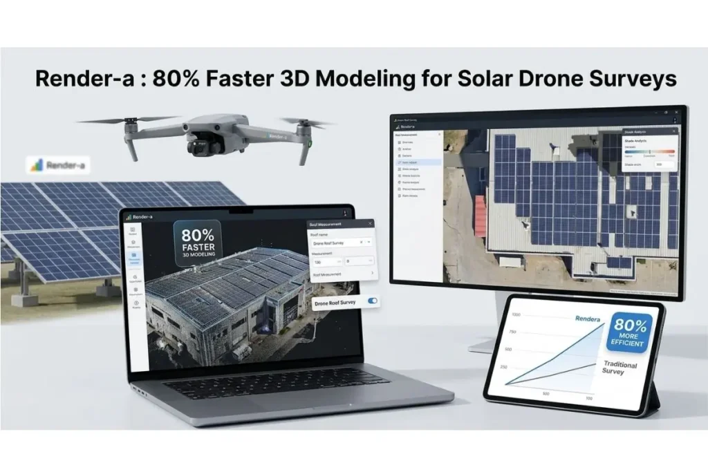
The emergence of professional solar drone survey software has fundamentally shifted this dynamic. By replacing manual climbing with autonomous aerial data collection, companies are discovering they can cut their proposal turnaround time by as much as 80 percent. This efficiency does not just save on labor costs; it fundamentally changes the sales conversion rate by allowing teams to deliver high-precision quotes while the customer’s interest is at its peak.
Eliminating the Risks of Manual Roof Assessments
The traditional survey is fraught with challenges that modern technology has finally rendered obsolete. Manual measurements often result in discrepancies of several inches, which might seem minor until those inches prevent the final row of panels from fitting during installation. These errors lead to costly redesigns and “truck rolls” that eat into the project’s profit margins.
Furthermore, the safety aspect cannot be overstated. According to safety statistics provided by organizations like the Occupational Safety and Health Administration (OSHA), falls remain a leading cause of workplace injuries in construction-related fields. By utilizing drone-based workflows, teams can keep their feet firmly on the ground while capturing a complete digital twin of the property. This transition to a “ground-first” approach is a hallmark of a modern drone roof survey, ensuring that the only time a technician needs to climb a roof is for the actual installation.
Precision Engineering Through Drone Data
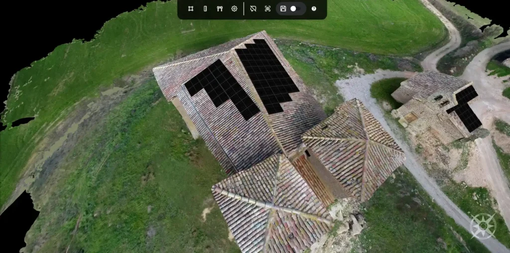
A drone does more than just take pictures; it captures thousands of data points that form a dense point cloud. When this data is processed through specialized 3D modeling solutions, the result is a millimetric-accurate representation of the site. This level of detail is critical for complex commercial projects where HVAC units, vents, and varying roof pitches make manual estimation nearly impossible.
When companies integrate advanced 3D land surveying tools into their workflow, they gain the ability to visualize the entire site topography. This is particularly useful for ground-mounted systems where the slope of the land and local vegetation can significantly impact energy yields. The ability to generate a high-fidelity model from drone imagery means that the preliminary design is no longer a “best guess” but a data-driven engineering plan.
Streamlining the Solar Proposal Journey with Render-a
The true power of capturing aerial data is realized when it flows seamlessly into the design phase. This is where Render-a excels, bridging the gap between raw drone imagery and a finalized sales document. Instead of forcing designers to hop between multiple software platforms, the integrated environment allows for rapid solar proposal preparation based on real-world dimensions.
Once the drone data is uploaded, the software enables automated panel placement that respects local fire codes and setbacks. This automation ensures that the sales team isn’t just selling a dream, but a viable system that the engineering team can actually build. The transition from a facade measurement or a rooftop scan to a 3D layout happens in minutes rather than hours, allowing for real-time iterations with the client.
The Critical Role of Shade Analysis in ROI Calculations
Perhaps the most significant advantage of using 3D modeling for solar is the accuracy of shade analysis. In the past, shading was estimated using handheld tools at a few points on the roof. Modern software simulates the sun’s path across the sky for every day of the year, accounting for every chimney, tree branch, and neighboring building.
By providing a granular look at how shadows move across the proposed array, the software calculates a more realistic expected energy output. This data is the backbone of a credible Return on Investment (ROI) forecast. Customers are much more likely to sign a contract when they see a 3D simulation of their own home, backed by rigorous climate data and precise geometric modeling. Research from organizations like the National Renewable Energy Laboratory (NREL) has consistently shown that higher accuracy in solar modeling leads to better long-term system performance and higher customer satisfaction.
Scaling Operations in a Competitive Market
For solar installers looking to scale, the math is simple: the more accurate proposals you can send out per week, the more projects you will close. Relying on a small team of specialized surveyors to visit every site is a linear growth model that eventually breaks. In contrast, adopting drone-based mapping allows a single pilot to survey multiple sites in a single morning.
This scalability is further enhanced by the ability to handle various types of projects within the same ecosystem. Whether the team is working on a residential home, a complex industrial warehouse, or a large-scale land development project, having a unified platform for 3D modeling solutions ensures consistency across the organization. It reduces the training burden on new employees and ensures that the brand’s output remains professional and accurate.
The Future is Digital
The transition to solar drone survey software is no longer a luxury for early adopters; it is becoming an industry standard. As the cost of drone hardware continues to fall and the capabilities of AI-driven modeling continue to rise, the gap between traditional installers and tech-enabled firms will only widen.
By focusing on speed, safety, and scientific precision, Render-a provides the tools necessary to thrive in this new landscape. Moving the survey process from the ladder to the sky allows solar professionals to focus on what they do best: designing and installing the clean energy systems of the future. The result is a more profitable business, a safer workforce, and a much happier customer base.


