While terrestrial laser scanners offer high precision, they are expensive, slow, and often overkill for commercial roofing and solar PV projects. Drone roof photogrammetry when processed through automated cloud platforms like Render-a delivers true-to-scale 3D models, millimeter accuracy, and actionable data in a fraction of the time and cost.
Capturing existing building conditions for solar panel layouts or roof renovations used to mean sending a team up a ladder with tape measures, or renting wildly expensive survey equipment. Today, achieving a precise roof measurement is a digital process. But when you need true-to-scale accuracy to guarantee your PV design fits perfectly, which technology should you trust?
The industry debate usually comes down to two options: terrestrial laser scanning (LiDAR) or drone photogrammetry. If you are an EPC company, a roofing contractor, or an architect, choosing the wrong data capture method can lead to mismatched panel counts, repeat site visits, and eroded client trust. Let’s break down exactly what each technology delivers and how modern workflows have crowned a clear winner for structural measurements.
The Quest for Precise Roof Measurement
In our field experience, a proposal is only as good as the baseline data. If you assume a roof has 800 m² of usable space, but fail to account for the exact slope or an unmapped HVAC unit, your shading analysis and bill of materials will be fundamentally flawed.
Achieving a precise roof measurement is about more than just finding the perimeter. You need the exact pitch angle, azimuth, parapet heights, and obstacle locations. You need a clean, reliable point cloud density to generate a workable 3D mesh. Historically, acquiring this level of detail required massive hardware investments and highly trained 3D modelers. Today, the expectations have shifted toward speed, safety, and scalable software integration.
3D Roof Scanning with LiDAR (Laser Scanners)
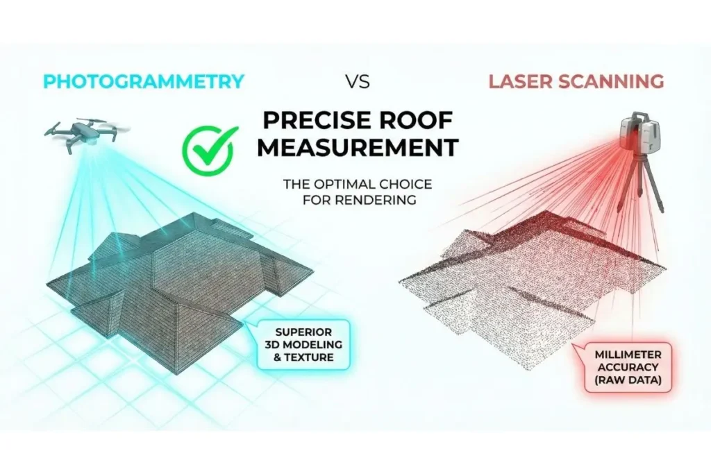
For years, Terrestrial Laser Scanners (TLS) were considered the gold standard for structural accuracy. Devices from brands like Leica Geosystems or FARO emit millions of laser pulses to measure distance via time-of-flight.
The Reality of LiDAR: There is no denying the mathematical accuracy of a laser scan. However, LiDAR has severe practical limitations for roof surveys. Because these scanners are ground-based or tripod-mounted, they suffer from line-of-sight issues. You cannot easily scan the center of a flat commercial roof from the street. Furthermore, LiDAR equipment requires a massive capital investment, and the raw point cloud data is incredibly heavy, requiring powerful workstations and complex software to clean up LiDAR noise before it can be used for PV placement.
Roof Photogrammetry (Drones): The Modern Standard
Flying a drone over a project site has completely revolutionized spatial data collection. By capturing high-resolution, overlapping photos from multiple angles, photogrammetry algorithms calculate depth and reconstruct the entire scene in 3D.
Why Photogrammetry Wins for Roofs: Drones eliminate line-of-sight issues entirely. An automated flight path captures every chimney, skylight, and roof plane safely from above. Furthermore, drones capture vital visual context. The photogrammetry 3D textures allow engineering teams to visually inspect roof conditions, identify material types, and spot potential structural damage from their desks.
The historical drawback to roof photogrammetry was the processing. Turning those photos into a measurable model used to require desktop software, manual mesh decimation, and hours of processing time.
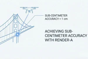
Achieving Millimeter Accuracy in 3D Scanning with Render-a
This is where the industry standard has shifted. You no longer need to be a photogrammetry expert or own a heavy workstation to extract millimeter accuracy in 3D scanning.
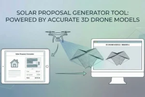
Platforms like Render-a have automated the entire backend. You simply upload your standard drone imagery, and the cloud-based engine processes the data into a true-to-scale 3D digital twin within hours.
Instead of dealing with raw point clouds, Render-a automatically computes the area, slope, and azimuth of every surface. Obstacles are tagged, and the roof slope data flows directly into your solar PV layout design. You can run shading simulations by hour and season directly on the model, and export bankable energy estimates to industry-standard tools like PVsyst. It bridges the gap between raw drone data and a final, brand-ready solar proposal all on a single platform.
FAQs
Do I need an RTK drone for accurate roof measurements?
While RTK/PPK drones provide excellent global positioning, standard high-resolution drones combined with our advanced processing engine are more than capable of generating true-to-scale, 1:1 measurable models for solar planning and commercial roofing proposals.
How long does it take to process a drone roof survey?
Manual processing can take days. However, using automated platforms like Render-a, the end-to-end flow from uploading drone photos to receiving a fully measurable 3D model is completed seamlessly in the cloud.
Can drone photogrammetry accurately measure roof pitch and azimuth?
Yes. When processed correctly, a 3D model generated from overlapping drone photos allows software to automatically calculate the exact slope and azimuth of every individual roof face, making it the ideal foundation for shading analysis and PV string predesign.
The days of risking team safety on steep roofs or investing heavily in slow, ground-based LiDAR are fading. The most efficient way to scale your solar or roofing operations is by leveraging the hardware you likely already own a drone paired with intelligent, cloud-based processing. Stop fighting with raw data and manual calculations. Take your drone captures, turn them into actionable 3D models, and generate bankable proposals instantly.
Ready to see how fast your workflow can be? Upload your first dataset and experience true-to-scale modeling with Render-a today.