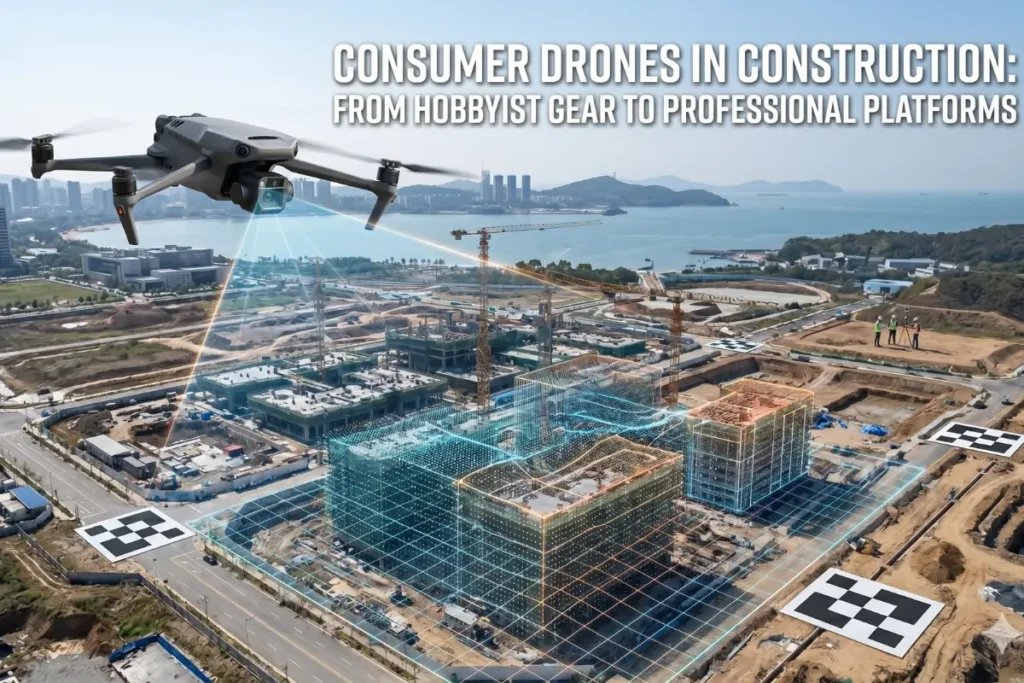
The Viability of Entry Level Hardware in Professional Contexts
The question of whether a consumer-grade drone can effectively handle the rigors of site analysis often arises when teams look to optimize their overhead. We have spent years navigating the intersection of hardware capabilities and software sophistication, observing how the gap between hobbyist gear and professional platforms continues to narrow. While a high-end enterprise unit offers integrated precision, a standard consumer drone remains a powerful asset for data acquisition if handled with a rigorous methodological approach.
Consumer drones can facilitate land surveying by capturing high-resolution imagery for photogrammetry, provided they are paired with Ground Control Points to ensure spatial accuracy. While lacking built-in RTK, these devices serve as cost-effective entry points for 3D scanning, enabling digital terrain modeling and progress tracking in various construction management environments.
Bridging the Accuracy Gap Through Ground Control
The primary challenge when using non-professional hardware is the inherent limitation of the onboard Global Positioning System. Most consumer units rely on standard satellite positioning which can have a margin of error ranging several meters. We mitigate this variance by implementing a network of physical markers on the terrain before flight. One method involves using heavy-duty markers while a second approach focuses on natural features, but both require measured coordinates. These markers, known as Ground Control Points, are measured with high-precision GNSS rovers to provide the necessary spatial anchors for the images.
This process ensures that the resulting high-fidelity topographical site models remains geographically relevant and serves as a reliable foundation for engineering decisions. By anchoring the flight data to these known coordinates, we transform a simple flying camera into a sophisticated tool capable of generating dense point clouds. This workflow is particularly effective for teams who require frequent updates without the prohibitive costs of specialized aerial crews.
Enhancing Construction Management with Photogrammetric Workflows
In the realm of modern construction management, the ability to visualize site progress in three dimensions is no longer a luxury but a necessity. Consumer drones equipped with decent sensors allow for the generation of orthomosaics and volumetric calculations that keep stakeholders informed. Integrating these outputs into a 3D scanning ecosystem allows for a holistic view of the project lifecycle.
Precision matters most when we move from broad site overviews to detailed structural analysis. For instance, when we transition from land mapping to building inspections, we often utilize autonomous flight paths for roof assessments to identify thermal leaks or structural wear. The data captured from these missions feeds directly into broader project databases, ensuring that every centimeter of the site is accounted for in the digital environment.
Technical Integration and Software Synergy
Hardware is only half of the equation in the modern surveying landscape. The true value of drone surveying lies in how the captured pixels are converted into actionable vectors and surfaces. Modern photogrammetry engines are now robust enough to compensate for the rolling shutter distortion often found in cheaper cameras. This software-side correction is vital for maintaining the integrity of the spatial data.
When we require higher fidelity for vertical structures, we lean into specialized techniques such as generating millimeter-accurate facade point clouds to support renovation or retrofitting projects. This level of detail requires a deep understanding of overlap ratios and gimbal angles, proving that the expertise of the operator often outweighs the price tag of the drone. We believe that a disciplined pilot with a consumer drone will consistently outperform an unskilled operator with the most expensive equipment on the market.
Regulatory Compliance and Professional Standards
Operating any aircraft for commercial purposes necessitates a thorough understanding of the legal landscape. Every mission must be conducted in accordance with geospatial positioning accuracy standards to ensure the safety of the public and the validity of the results. This involves not only pilot certification but also a commitment to data privacy and site-specific permissions.
Beyond the legalities, we must also consider the environmental variables that affect small aircraft. Consumer drones are typically lighter and more susceptible to wind drift, which can impact image sharpness. To counter this, we plan missions during peak lighting conditions and low-wind windows, ensuring that the raw data remains crisp and suitable for high-end processing. This attention to detail is what separates a casual flyover from a professional-grade survey.
Economic Advantages of Hybrid Surveying Models
The adoption of affordable aerial tools provides a scalable solution for firms that are not yet ready to invest tens of thousands of dollars in LiDAR or RTK-enabled platforms. It allows for a more democratic approach to site documentation where daily or weekly captures become financially feasible. This frequency of data collection is a game changer for detecting discrepancies early in the build process.
By leveraging these accessible tools, we can provide comprehensive 3D scanning services that cover vast areas at a fraction of the traditional cost. Whether it is calculating the volume of a stockpile or verifying the placement of utilities, the consumer drone serves as a reliable bridge. It is an invitation to innovate, encouraging project managers to embrace digital transformation without the fear of excessive capital expenditure. Understanding the limitations is the first step toward mastering the possibilities of this technology.