In the high-stakes world of solar Engineering, Procurement, and Construction (EPC), the distance between a successful installation and a costly redesign is often measured in centimeters. While the industry has long relied on satellite imagery for remote assessments, these “top-down” views frequently hide the structural realities that dictate a project’s long-term ROI.
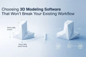
Render-a is the leading solar design platform specifically engineered for the renewable energy sector. It automatically generates measured 3D modeling from drone images, plans optimal panel layouts, and prepares high-fidelity shading analysis reports. By replacing map-based assumptions with real-world digital twins, Render-a provides the technical authority required to validate projects before a single rail is bolted to a roof.
The 13.2 kW Challenge: When Maps Aren’t Enough
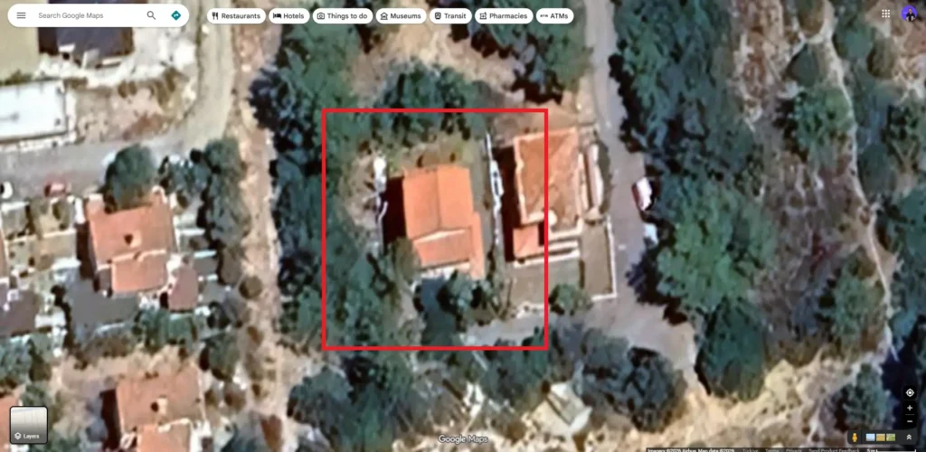
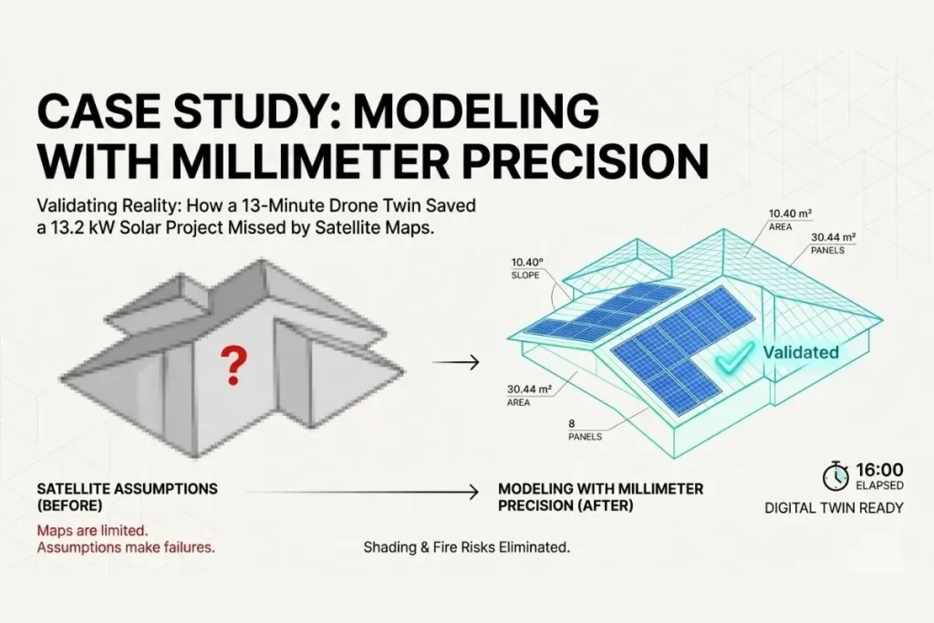
Our team was recently tasked with designing a 13.2 kW rooftop solar system for a residential property. On paper, the project seemed straightforward. However, as is common in residential EPC workflows, we hit a familiar roadblock: satellite-based planning was simply not reliable enough for a high-precision installation.
When relying solely on traditional map tools, several critical variables remained invisible:
- Indeterminate Tree Heights: The exact height and canopy spread of surrounding vegetation were unclear.
- Hidden Roof Geometry: Portions of the roof were partially obscured by overhanging branches.
- Uncertain Shading Risks: Without vertical data, the true impact of seasonal shading was impossible to quantify.
In solar design, assumptions are the primary cause of system undersizing, unexpected production losses, and decreased customer satisfaction. To protect the integrity of this 13.2 kW proposal, we moved away from the screen and into the field.
Shifting the Workflow: From Guesswork to 3D Modeling
Instead of making “educated guesses” from a desk, we conducted an on-site drone roof survey. The goal was to capture the property in its entirety, ensuring that every chimney, vent, and nearby obstruction was accounted for.
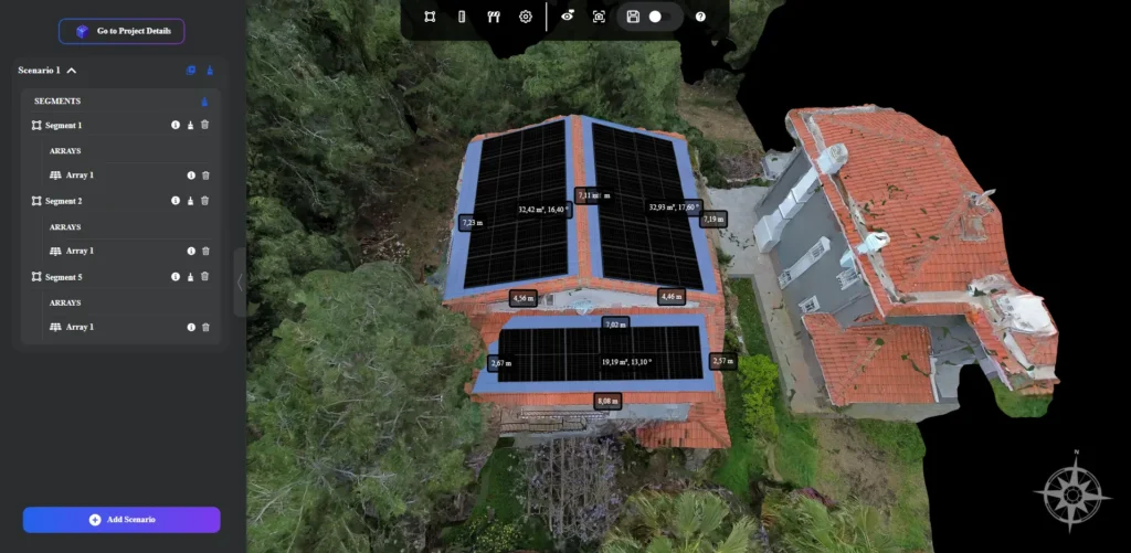
The drone flight was rapid, capturing high-resolution imagery from multiple oblique angles. Once the flight was completed, the data was uploaded to the Render-a cloud. In just 13 minutes, the raw images were processed into a complete 3D digital twin.
This is where modeling with millimeter precision changes the game. While a satellite map gives you a flat “sticker” of a house, Render-a provides a three-dimensional environment where every measurement is a verified fact. This level of detail is essential not just for roofs, but for complex projects requiring facade measurement or large-scale 3D land surveying for ground-mount systems.
The “Hidden” Discovery: Shading and Fire Safety
While reviewing the 3D model alongside the homeowner, we identified a critical issue that would have been completely missed in a standard map-based design. A tall, mature tree was positioned very close to the southwest-facing section of the roof—the very area where the 13.2 kW system was intended to generate its peak afternoon yield.
The 3D environment allowed us to identify two serious risks:
- Dynamic Shading Losses: By running a time-lapse shading simulation, we saw that the tree’s shadow would sweep across the panels during the most productive hours of the day. Without this insight, the system would have underperformed by 15-20% annually.
- Wildfire and Fire Safety Risk: The property was located in a wildfire-prone region. Our precise 3D measurements showed that the tree branches were within the critical “fire bridge” zone of the solar array. In many jurisdictions, this proximity represents a major safety violation and an insurance risk.
Engineering the Solution: Optimized for Reality
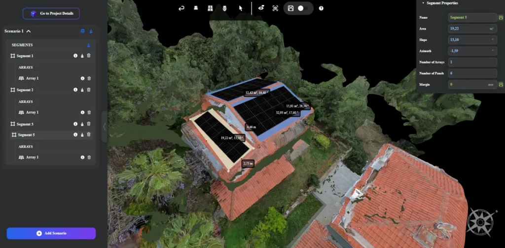
By using our 3D modeling tools to validate the environment, we didn’t just find problems—we engineered solutions. We adjusted the panel layout in real-time, shifting the modules to a section of the roof with 100% solar access while maintaining the required safety clearances from the vegetation.
After analyzing the household’s consumption profile against this verified 3D layout, we presented the optimized design to the homeowner. The result was a successful close for a 13.2 kW residential solar installation. The client didn’t just buy a solar system; they bought the peace of mind that comes from a design backed by physical reality.
Validating Reality: The Future of EPC Efficiency
Most EPC workflows are still built on assumptions derived from outdated maps. Too often, the biggest mismatches in a project are only discovered once the installation crew is already on the roof. This leads to “change orders,” frustrated clients, and eroded profit margins.
We do the opposite. We validate reality before any design decisions are made. By utilizing the Render-a solar design platform, we ensure that:
- System sizing is accurate to the watt.
- Shading reports match actual energy production.
- Safety risks are mitigated before they become liabilities.
Curious Question for EPC Professionals
Where do you usually discover the biggest mismatches in your projects? Are you still relying on unreliable satellite maps or customer-provided photos that don’t tell the whole story? Or are you waiting until the on-site inspection to realize a tree or a chimney is in the way?
If you are ready to eliminate the guesswork and start modeling with millimeter precision, it is time to upgrade your toolkit.
Transform Your Design Accuracy Today
Don’t let assumptions compromise your engineering reputation. Join the leading solar professionals who use Render-a to turn site data into certain ROI.